Following are our two main local resources for forecasted inundation and their associated gauges/stations. First is the Stevens Institute’s Stevens Flood Advisory System at Davidson Labs or SFAS (covering both NOAA’s gauge at Sandy Hook (Coast Guard Station) along with the USGS’s Shrewsbury River gauge (Rumson Rd (520)). Second is NOAA, providing forecasting only for their gauge at Sandy Hook. Both SFAS and NOAA take into consideration the many forecasting variables (ground water, stream flow, lunar, forecast weather etc…). Historically both forecasting models run very close in their inundation predictions for Sandy Hook. Again, SFAS provides the only inundation forecast for the Shrewsbury River Gauge.
Available alerts/notifications are as follows… SFAS’s email alerts will provide you with notifications any time a forecasted water level (at the station of your choosing) exceeds the Minor Flood Level. Second, the USGS Shrewsbury River Station provides email alerts based on your selected water level, but these alerts are in real time, not forecasted (you don’t get a notification until the water has actually risen). NOAA does not provide for any notifications.
We have created an email notification for NOAA’s Sandy Hook station, it allows you to select the forecasted water level you wish to be alerted at. A notification is sent every 12 hours from the first triggered alert and continues until the forecasted level falls below the threshold. This additional method allows for some filtering of alerts based on your actual needs.
Links to NOAA’s Sandy Hook Station and the USGS’s Shrewsbury River Station are here.
Suggestions, please contact us.
NOAA Coastal Inundation Sandy Hook 72hr Forecast
No Data Found
Chart refreshes once per minute
API data sourced from NOAA and USGS
For reference, a prediction of 7.3’ – 7.6′ (conservatively) above MLLW at the Hook, dependent on strength, direction of wind, and amount of rain will flood Osborne and overwhelm pumps. At this point, flooding all of the downtown basin streets.
Subscribe Here for Forecasted Flood Notification
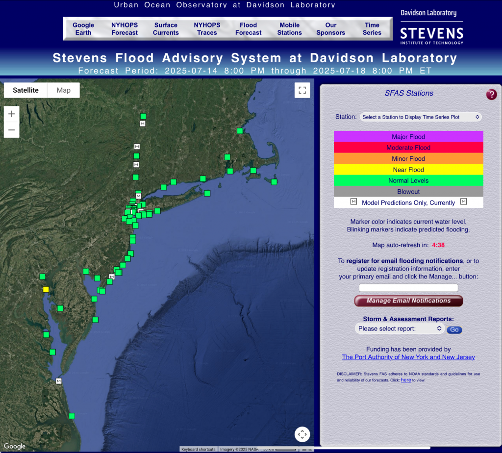
Stevens Flood Advisory System at Davidson Laboratory
The Stevens Flood Advisory System (SFAS) displays both current and forecast water levels at several locations, and compares them to “action” levels for flooding or blowout-tide, as available. Each SFAS location is displayed as a marker on the SFAS map. The marker will be either a square to indicate tidal stations, or a circle to indicate hydrological, non-tidal stations. The control box on the right displays a color legend for “action” levels.
The color of the markers indicates the current water level, as observed by real-time field instruments at these locations. If a location lacks such an instrument, or if for any reason no observations have been received over the past two hours, that location’s marker is white with “M” indicating that only model forecasts are currently available. If flooding or a blowout-tide is predicted within 96 hours from now, the “forecast period” shown on the top of the main SFAS page, then the marker will blink.
If you click on a location marker, an “info window” will appear which notes the current observed water level and any forecast warnings (e.g., ‘normal’ or ‘minor flood’) for that station in the coming 4.5-day period. By default, an ensemble of forecast predictions created at the Davidson Laroratory is used in SFAS.
To display a time series plot, which includes 96 or more hours of forecast, with observed data when available, click on the ‘Show Time Series Plot’ in the info window, or use the Station drop down in the control panel to select a station. The Stevens ensemble for the selected location will be displayed first. Where available, you may select to display a different forecast time series from a number of forecast models.
If you would like to receive email notifications of predicted flooding, enter your primary email address in the control panel to the right, and click the ‘Manage Email Notifications’ button. On the page that appears, you may select the stations for which you’d like to receive notifications, and, optionally, provide an alternate email.


Recent Comments